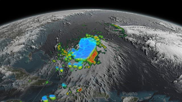
Hurricane Joaquin crouches over the Bahamas on Thursday, hammering the island nation with high winds and rain.
Even though they’re large enough to see and track from space, hurricanes can be surprisingly difficult to predict.
Many of the models meteorologists use to predict the path of a hurricane are coming into agreement for Joaquin after days of forecasting anything from a direct hit for the U.S. East Coast to a straight shot out to sea. Previous charts showing the possible paths of Hurricane Joaquin looked like someone spilled a plate of noodles.
For now, it's looking more likely this category 4 hurricane will stay out to sea.
Joaquin's path has been especially difficult to anticipate because of other atmospheric phenomena that weather forecasting models aren't necessarily prepared to deal with at this time of year.
They include a high pressure system over the North Atlantic that could potentially block Joaquin from heading out over the ocean, and a low pressure system on the east coast that could suck the hurricane towards shore.
Some forecasting models, like the U.S. Global Forecast System (GFS), emphasize the low pressure system and show Joaquin coming ashore on the East Coast. But the European model—which correctly predicted the path of Superstorm Sandy days before other models—shows Joaquin staying out at sea because it will be too far south to be captured by the low pressure and drawn to shore.
There's just so much data on what could affect storms—including cloud formations, the rotation of a storm, its location, wind speeds, barometric pressure readings, and sea surface temperatures. Every model deals with the numbers in slightly different ways, leading to wide variances in forecasts. (Watch an explanation on why hurricanes can be so destructive.)
More Power
There are two big reasons why the European model is usually more accurate than U.S. models. First, the European Centre for Medium-range Weather Forecasting model is a more sophisticated computer program that incorporates more data.
Second, the European computers that run the program are more powerful than their U.S. counterparts and are able to do more calculations more quickly.
"They don't have any top-secret things," said University of Miamimeteorologist Brian McNoldy in an earlier interview. "Because of their (computer) hardware, they can implement more sophisticated code."
A simple solution to improve U.S. weather forecasting capabilities would be to give the National Weather Service more computing power, said Cliff Mass, professor of atmospheric science at the University of Washington in Seattle, in an earlier interview.
But until U.S. weather forecasting models can catch up to European programs, American meteorologists will have to make do with what they've got.
With reporting by Willie Drye and Peter Miller
Follow Jane J. Lee on Twitter.
Jason Samenow, weather editor for the Capital Weather Gang at the Washington Post, explains how forecasters rely on computer models to help predict the weather, and why their forecasts may be more accurate than you think.

Nenhum comentário:
Postar um comentário